There is currently approximately 5 km of decaying ice above the beechwood dam with 3 km jam. Then open water all the way to Grand Falls.
The Grand Falls head pond currently has 30 km of decaying ice cover above the dam. Then a 5.5 km ice jam in place.
When the ice releases in Grand Falls, we will see a rise in water levels. Fortunately, our ice is currently decaying in the deeper part of our head pond.
Rain and warmer temperatures will result in a significant increase in water flows this weekend. Flows are anticipated to increase from 105,000 this morning to 149,000 on Sunday.
As always, we encourage property owners to monitor the river and take steps to reduce the impact of possible flooding.
Please see the stats below with projected the weather and river flows. Be sure to visit our bridge cam.
Our gentle spring continues to be supported by our slow melt this year! Enjoy your day and stay safe!
Please - Stay away from the edge of the river!
River Flow Rates & Elevation - Beechwood Dam
| Beechwood Flows – Today & Projected | |||||
| 7am Today |
Fri | Sat | Sun | Mon | Tues |
| 105,000 | 113,000 | 137,000 | 149,000 | 141,000 | 124,000 |
| Water & Ice - Water elevation normal level. Water does not cross any roads in the municipality until we reach and elevation of 257.25 ft. Roads – All roads open EOC Activation Level - Level One Monitoring Schools - All open Action Planned - Monitoring with NBP, ELG, PS, and EMO. Next update - Friday Safety - Please remember that our ice erodes from the river flow on a daily basis. Please be safe and use common sense around waterways. Please use bridge for all river crossings. |
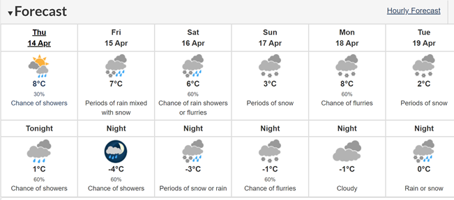
Forecast issued: 11:00 AM ADT Thursday 14 April 2022
Today Increasing cloudiness. 30 percent chance of showers late this afternoon. Tonight Cloudy. 60 percent chance of showers this evening. Periods of rain beginning near midnight. Fog patches developing near midnight. Amount 5 to 10 mm. Low plus 1.
Fri, 15 Apr Periods of rain ending in the afternoon then clearing. Rain mixed with snow in the morning. Fog patches dissipating in the afternoon. Rainfall amount 5 mm. High 7. Night Cloudy periods with 60 percent chance of showers. Low minus 4.
Sat, 16 Apr Cloudy with 60 percent chance of rain showers or flurries. High 6. Night Periods of snow or rain. Low minus 3.
Sun, 17 Apr Periods of snow. High plus 3. Night Cloudy with 60 percent chance of flurries. Low minus 1.
Mon, 18 Apr Cloudy with 60 percent chance of flurries. High 8. Night Cloudy. Low minus 1.
Tue, 19 Apr Periods of snow. High plus 2. Night Rain or snow. Low zero.
To receive these updates click on the following link AND SCROLL to the bottom of the page. Input your name and email, then select the EMO updates box and push subscribe. http://perth-andover.com/.
In the case that we have a mandatory evacuation, those in the low-lying areas, along the river's edge that must evacuate will need to call Red Cross at 1-800-222-9597 to register.